FS · Chippewa National Forest
Mabel Lake
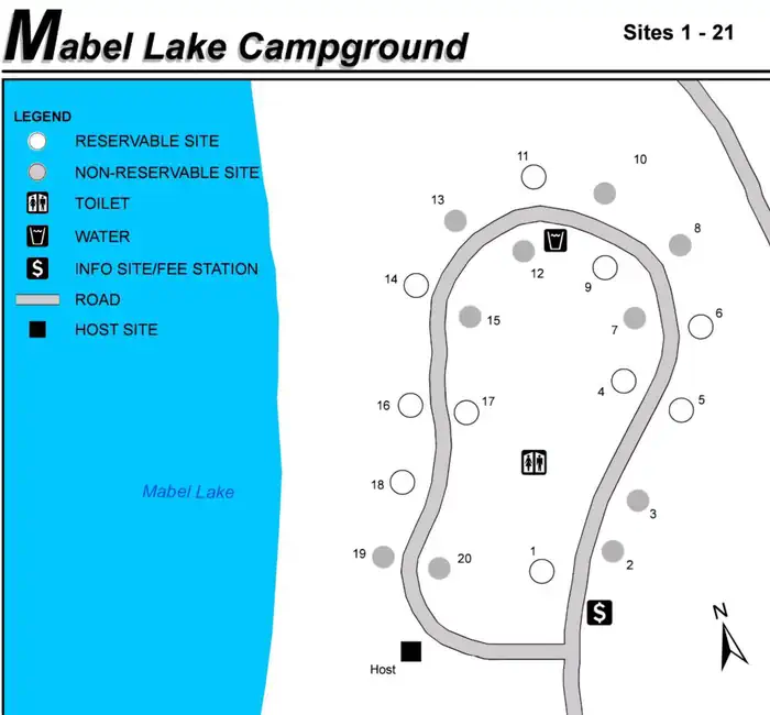
19 of 21 sites fit 38 ft
Book one of 19, 11, 10, 06, 02, 05 and 13 more
- Longest for your rig
- 74 ft
- Booking
- Reservable
- Hookups
- water
- Entry
- Back-in only
- ADA sites
- —
- Elevation
- 1,345 ft
- Vehicles
- up to 2
Book on Recreation.gov →the official reservation system; we take no cut
Every bookable site
The 19 sites that take a 38 ft rig, drawn where they sit.
Fits your 38 ft rig — 19 sites
1974 ft driveway · 16 ft wide1169 ft driveway · 16 ft wide1066 ft driveway · 17 ft wide0664 ft driveway · 14 ft wide0259 ft driveway · 15 ft wide0558 ft driveway · 14 ft wide0858 ft driveway · 15 ft wide2058 ft driveway · 12 ft wide0356 ft driveway · 16 ft wide1455 ft driveway · 14 ft wide0753 ft driveway · 13 ft wide2152 ft driveway · 14 ft wide1549 ft driveway · 11 ft wide1348 ft driveway · 14 ft wide1848 ft driveway · 16 ft wide0147 ft driveway · 14 ft wide1247 ft driveway · 13 ft wide1646 ft driveway · 14 ft wide1746 ft driveway · 11 ft wide
Too short for 38 ft — 1 site
Length never published — 1 site
Within 60 miles
| Map marker# | Campground | Distance | Sites | Longest for your rig | Hookups |
|---|---|---|---|---|---|
| 1 | Leech Lake Rec Area | 15 mi NW | 77 | 99 ft | electric · pull-through |
| 2 | Stony Point | 19 mi W | 43 | 45 ft | electric · pull-through |
| 3 | Winnie Dam Campground - USACE | 26 mi N | 22 | 98 ft | electric · pull-through |
| 4 | Cross Lake Recreation Area | 26 mi S | 122 | 99 ft | electric · pull-through |
| 5 | Pokegama Dam Campground | 27 mi NE | 21 | 79 ft | electric |
| 6 | Winnie Campground - USFS | 28 mi NW | 33 | 70 ft | none |
Everything else on record
- Bookable sites
- 21
- Longest driveway
- 74 ft
- Max occupancy per site
- 8
- Reservable sites
- 10
- Coordinates
- 47.0498, -94.0719
- Elevation
- 1,345 ft
Sources
- Recreation Information Database (RIDB) · fetched from
https://ridb.recreation.gov/api/v1/facilities/10191080· retrieved 2026-08-17 · public-domain - USGS Elevation Point Query Service · fetched from
https://epqs.nationalmap.gov/v1/json· retrieved 2026-08-17 · public-domain